Freedom of the Hills: Black Cap Mountain
Here is another hike in the Lake Region and the White Mountains that readers are encouraged to try. Hiking is a great way to get outdoors during any season of the year and enjoy our special corner of Maine.
By Allen Crabtree
Guest Writer

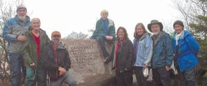
THE DENMARK MOUNTAIN HIKERS at the summit of Black Cap Mountain at the Anna Stearns memorial on a foggy wet day. May 4, 2012. (Photo by Allen Crabtree)
Black Cap Mountain is the highest peak in the Green Hills Preserve and offers fine views from its summit of the Green Hills range, Cathedral and White Horse Ledges, and Mount Washington.
It is an easy hike with some delightful rock scrambling on the bare granite ledges at the summit. The Black Cap Trail begins at a parking lot on Hurricane Mountain Road and runs almost level through spruce woods, then climbs at a moderate pace through mixed hardwoods to the ledges at the top.
There is an information kiosk at 0.5 miles from the trailhead, at 0.7 miles the Cranmore Trail leaves to the right, and at 0.8 miles the Black Cap Connector Trail leaves to the right. The main trail is well marked with pink blazes and signs at the trail junctions.
Black Cap is located east of Cranmore Mountain. In 1951, Cranmore obtained an easement on 500 acres of land on Black Cap with plans to expand the ski area to the top of Black Cap. Had this happened, Cranmore would have seen an increase of 700 vertical feet to 1,800 feet, making it the second highest ski area in the Mount Washington Valley. However, through the efforts of local conservationists, The Nature Conservancy purchased 2,822 acres of the Green Hills in 1990, effectively stopping the proposed ski area expansion.
A ledge at the summit of Black Cap is inscribed to Anna B. Stearns who was instrumental in preserving the Green Hills for all to enjoy. The inscription reads, “The Green Hills, preserved by The Nature Conservancy through the generosity of Anna B. Stearns as a memorial gift to her mother and father, 1990.â€
This was a delightful, easy hike for the Denmark Mountain Hikers and we recommend it for children as well. The Black Cap Trail is well used, but we have never found the summit crowded on our several excursions there.
Hike facts
Black Cap Mountain is located in Carroll County, North Conway, N.H.
Difficulty: Easy
Trail distance: To the summit (one way) – 1.1 miles
Hiking time: To the summit (one way) – 1 hour
Elevation: 2,369 feet
Vertical gain: 650 feet
Coordinates: 44o03’21â€N 71o04’00â€W
Directions: To the trailhead, from US 16/302 in North Conway at the scenic overlook, take Hurricane Mountain Road east 3.8 miles to the Black Cap Mountain trailhead and parking lot on the right side of the road. Hurricane Mountain Road is steep and winding and is not maintained in winter.
The trail to Black Cap is well marked with pink blazes and trail signs at the trail junctions. The trail passes through the Conway State Forest and lands of The Nature Conservancy in the Green Hills Preserve.
What to bring: Good boots, rain or wind gear, touring poles, tick and mosquito repellant, sunglasses, water and snacks, personal first aid kit, map and compass, and cell phone. Let someone know your hiking plans before you leave!
Next time: South Moat Mountain, Conway, N.H.

