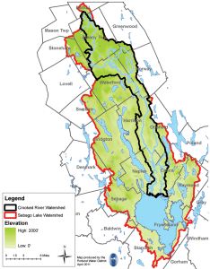
Watershed Survey to Look for Pollution on Crooked River
 A volunteer watershed survey at Crooked River will be conducted starting in May.
The survey is a joint project between the Cumberland County Soil & Water Conservation District, the Maine Department of Environmental Protection and the Western Foothills Land Trust.
The Crooked River supports one of only four known indigenous populations of landlocked Atlantic salmon in Maine. The landlocked salmon has brought international acclaim from anglers seeking this type of fishing experience and researchers seeking to restore salmon populations throughout the world. The Crooked River also supplies over 40% of surface inflow to Sebago Lake, which is the reservoir for the Portland Water District, a utility that supplies drinking water to 200,000 customers.
The survey will focus not only on the riverbanks, but also on the entire watersheds. A watershed is the land that drains to a water body by surface runoff, tributary streams, springs, and groundwater recharge. Crooked River’s watershed encompasses approximately 120 square miles.
Water quality monitoring has found that the Crooked River is exhibiting signs of stress that is likely the result of polluted runoff that flows into the river from its surrounding watershed. The rising development pressure throughout the watershed is an anticipated source of this stress.
Through the survey, volunteers from around the watershed will be looking for sites where polluted runoff takes place. Eroding sediment carries phosphorus, a plant nutrient, as a hitchhiker. Activities like construction, road building, land clearing and even small residential areas with bare soil or sparse vegetation can release sediment into the watershed. If too much phosphorus runs off from the land and enters a water body, nuisance algae growth can occur. In severe cases, mats of algae choke out fish, ruin water quality and recreation. Furthermore, increased sediment deposition may create favorable habitats for invasive aquatic species. Once these problems occur, they recur and are very expensive to fix.
Road runoff (which may carry oils, grease and other toxic substances), the overuse of lawn fertilizers, failing septic systems, and pesticides can also be a problem for rivers, lakes and streams. And, these pollutants don’t have to originate at the river’s edge to affect Crooked River’s water quality. Sediment, phosphorus and other contaminants may wash into the river from sites high up in their surrounding hills. That’s why the survey will look at the entire watershed of each lake.
The Cumberland County Soil & Water Conservation District works cooperatively with landowners to protect natural resources. Information collected in this survey will not be used for regulatory or enforcement purposes. Rather, it is the first step in a long-term program to work with the community to correct pollution problems in the Crooked River Watershed.
For more information, call Betty Williams, senior project manager at 892-4700 or e-mail betty-williams@cumberlandswcd.org at the Cumberland County Soil & Water Conservation District.

